


These lines that mainstream science tries so hard to dumb themselves down to avoid a real explanation can be solved in one instant if you know what you’re looking for. I didnt even have to look. I was sitting at the dinner table thinking about the canal network of the Pre-Reset world and it came to me in a flash and I knew it was correct before I even looked. Certainly I found more than I hoped, here is more visual evidence of what many, for lack of a better term, call the ‘Mudflood’.
Its undeniable, canals leave a recognizable shape and movement and you can compare with places today that still utilize the old grid. Southern Florida is one close to home. The Army Corp of Engineers tries to steal credit but everything they do is to cover up the Reset or support the current paradigm lie. There is no way possible the whole tip of Florida was dug out by them. They will try to compartmentalize localize sections to make it seem like a less intensive project and who’s gonna ever know? Unless you go and look for yourself the scale is incomprehensible. Even the ones that do look, say from an airplane, wont know what they’re looking for and on top of that even in an airplane you are still too close to see the full effect.

Venice is the biggest mainstream canaled urban area people know, the thing about Venice is its so crowded its hard to see the grid. There is a Venice in Cali, they even have a site called the Venice Canals but if you are being directed there its a set-up. This is the law of NWO. Only mention your own works. The Venice Canal project in America is just about 6 blocks, a postage stamp, a fucking joke.
The entire South American continent is either a rocky mountainous inhospitable barren wasteland or flooded rainforest where you cant pentrate the canopy. The sliver of land where they meet is where we will be focusing today. This is where the so-called Nazca Lines are. We will also look on both sides and see where the evidence takes us. I haven’t been studying this worldwide canal thing for long. I came about it by accident and once I saw what to look for I kept finding more of the same all over the world. I will make a post about this world grid and have been considering stepping over the line into video making, since its so difficult to get a full appreciation from a still shot.
I see evidence that the entire west coast of S. America was wiped out to erase the past civilization. Forget nukes, as if they were even real, this was done with traumatic geological events. I cant explain the process yet, you just have to look for yourself. This was done relatively recently too, you can see the state of erosion and compare to other places across the world. They use atmospheric conditions to explain how well preserved everything is but since the weather is under control too that doesn’t count
Plus the mainstream tries to mislead you, they subconsciously put into your mind statements about how the lack of rainfall means there hasnt been much erosion. Thats some bullshit. The reason the area is in such good condition is bc it just happened, is still happening. Shows like Ancient Aliens and Histories Mystery’s always point you toward the sky. Runways, spaceship signaling… Its an insult. They even set up the tourist traps like the astro-not that makes you go into outer space mentality. These individual sites are so tiny you might see them from an airplane but, again, the scale is so massive when you zoom out enough to see the complete picture the tourist trap sites arent even visable.
Heres a few images I am going to post now but I gotta go to my wage-slave job and when I get back I can organize them a little better. Im sure my regulars and anybody else with a handful of brain cells wont need much explaining. The images speak for themselves. Ive already been talking too much…


Here are some sites in India that still function as runoff collection and distribution.


Space Lazers
I’m still collecting evidence for this in a loose way. Right now I’m leaning toward several different threads concerning the whole continent. The Amazon rain forest is Terra formed. I haven’t found direct evidence yet but Im confident thats correct from reading the fake truth guru disinfo. Im not even sure what the proper word is yet. Terra forming would probs be most accurate, a form of geo-engineering. Mud-floods, title waves, volcanoes all trying to erase evidence.
The canals themselves are cut with energy tools. We know them as DEW’s bc we only see the weaponized effects. Not only did the Direct Energy Beam cut the canals but they are being used to erase them.. Look at the one pic you will know what one im talking about when you see it. The white circles with black dot in the center are an identifiable effect from laser etching. Not just here but in all deserts including the middle east and Africa we find similar. There is something under the ground in half the continent causing the earth itself to change


Directed energy (lasers) cut and drilled on mineral deposits. 1, 2, 3
Here is an article from CERN about plasma etching that results in formsations like this. This is almost identical to some of the canal beds. Its a technical paper, not really much help, its a springboard

‘Ablation’, is the term for the mark left at the site of directed energy activity.
I cant begin to pretend to understand the technical jargon of the process below. I understand that it involves salt. It is mentionable bc of all the salt flats throughout the region. Pink salt specifically, in case that matters. link


Terra forming South America
There are some large scale traumic geological events that have taken place relatively recently, some of which are still taking place today. It just so happens to be overencroaching into the old canal bed territory. like something happened in the middle and is working its way towards both ends. I just want to remind everyone this is partly speculation. Im just thinking out loud.


Silver Bullet
This is one of the ways they trick you. They make you syay in the wrong perspective by puttong the cheezy fake bullahit ones up that keep you too low. Take a couple steps back


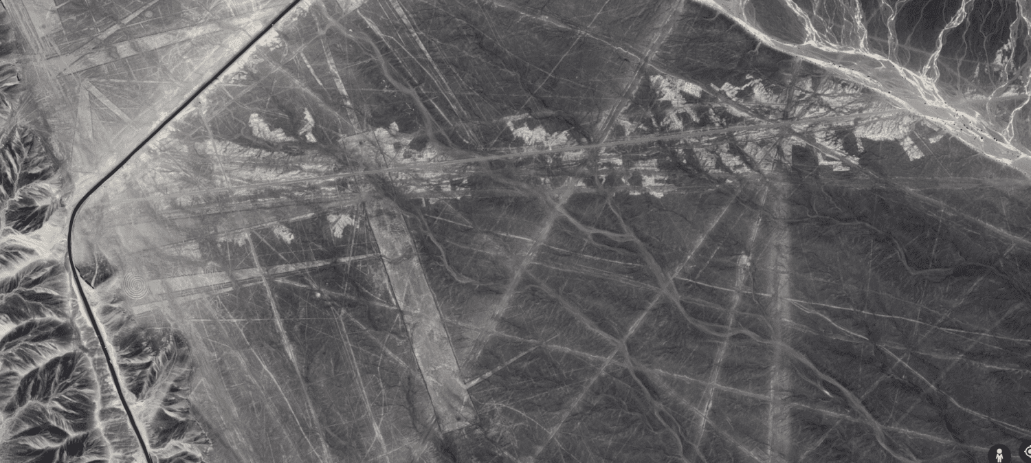
This is a powerful image. what do you See?
I’ll walk you through what I see.
The resevoirs are at the bottom of the mountains to collect run off. The road is run right thru it to try and btake it up, to provide cover for breaking it up farther with other methods.
The white marks around the edges are laser etching. This is like getting a laser face lift. They are using laser removal not unlike one would use to get rid of wrinkles. The patterns here lead me to suggest their capabilities are limited, or they just dont care that much and arenot concerned past getting rid of the most obvious spots.The process leaves a signature mark. We return here.
Athe the bottom is a fresh mudflood, wiped out a pretty good swath. The flower is too tiny to see.

Ah Shit, you know what, I almost missed the best part. Did you catch the spiral in there?


What The…?
This is just one small sample. These things are everywhere and its difficult to scale something. I am not discounting natural fractal patterns. A small rock chip and an entire mountain have the same form the differance is your perspective


Compare this to the lines off the New York islands, found in my Winged Lion symbolism paper, link, If you liked this youre gonna fall over when you read this.

And This ?

These faint lines are at the end of something else. Its newer than the ols canal network. You can tell bc its the only thing on the fresh lava. I know its not lava but for lack of a better term I’ll stick with something most ppl are familiar with. The snowy region on the left is a different frame, no matter how close you get the snow effect gets darker. This is the G.E. spooks trying to hide the area. Just wait.


One sure way to cover something up is to add something like a fracking operation. I first noticed this with strategically placed golf courses, now you can top that with windmill farms, surface mining operations, and oil derricks, all of which are in the Andes. To one-up that the whole desert. So far as I have found deserts are geo-engineered to cover up the old system. Opposite that face are the rainforests, although, I haven’t looked specifically at the African interior, like the Congo, the Sahara def has features that indicate Terra-forming operations. (I wonder how I could confirm the age of the Redwoods in Cali?)


I wish the above images had turned out better. They are hiding something behind a big black shadow, but its not really a shadow. It moves around and lightens and darkens as you try to zoom in. There is a major split in the crust here or something of that nature they do not want people to be looking at. Those spire things do not look natural or real. It looks like a demon or monster face with horns. Creepy, right? The second image is of the base where the horn meets the head. looks like a signature of some kind, like when an artist tags the corner of their work where you wont see it unless you’re looking. click to enlarge.


The volcano field stretches for hundreds of miles, pumping fresh bedrock to cover up the once-populated coast of S America. You cant even see the scale from a pic, the one is 400 miles of volcanoes and doesn’t even cover the whole field
Normie confirmation

Here is a paper from an academic source that mocks this subject by pretending to need all these futuristic technologies to see the canals and causeways. So I have been thinking about drainage after the mudflood, the canal were filled in and act as french drain tile. Drainage was one of the first big engineering feats at the beginning of the repopulation.
The source is the University of Bonn, I am familiar with them from my Asian Reset report, so I already know they fake ancient cultures.
“Indeed, the architecture found in both Cotoca and Landíva may well have required the greatest amount of skilled labor of any construction from the same time period in the entire continent.”

Ancient Rock Art Sites Found in Amazon


